UC 5: Accident/ vehicle breakdown warning
Operation use case
Definition
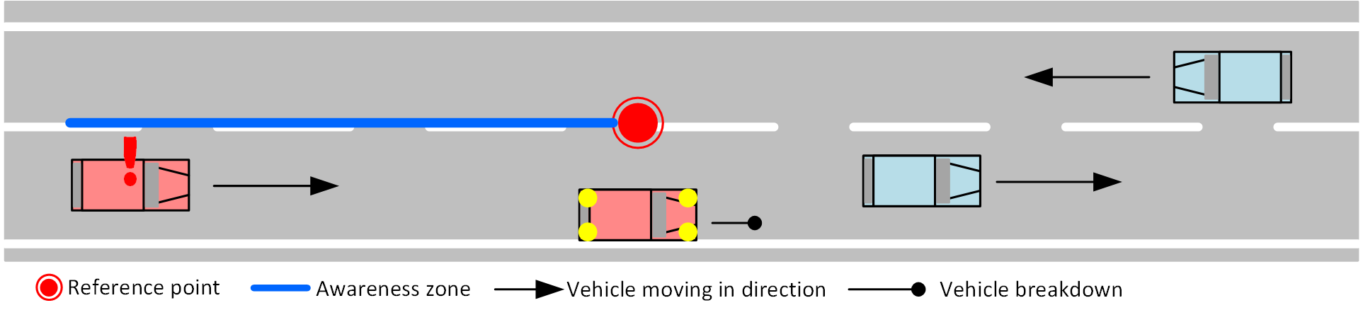
Warn and inform about incidents (traffic accident or vehicle breakdown) that the road user will encounter.
Traffic accidents: DENM does not allow for quantifiable details on the accidents’ gravity and impact on traffic: can be anything from a small accident on the hard shoulder upto a fully blocked roadway in both directions. . The awareness zones in the DENM messages will include all directions where there is impact for road users.
Broken down vehicles: Can be any stopped vehicle, within Mobilidata is currently no information about the cause for stopping available. Also: vehicle can be present ON the roadway, or on the hard/soft shoulder. The message type in use can provide the cause and possible sub causes.
Operational Road Environment
- Territory: Flanders
- Border passing cases: N/A
- Road class: All
- Time restrictions: None
- Weather restrictions: None
- Special restrictions: None
MI & Historical archive
DENM information
| Causecode | Description | Subcausecode | Description |
|---|---|---|---|
| 2 | Accident | 0 | unavailable |
| 1 | multiple vehicles accidents | ||
| 2 | heavy accident | ||
| 3 | accident involving lorry | ||
| 4 | accident involving bus | ||
| 5 | accident involving hazardous materials (ADR transports) | ||
| 7 | Unsecured accident | ||
| 94 | Stationary vehicle | 0 | unavailable |
| 2 | Vehicle breakdown |
- Default time to live 10 minutes (600 sec’s in the DENM message).
- Updated based upon more or more reliable data and system awareness of extended life-time
- Lat/Long position of event (can be updated if a better data source corrects the position)
- Awareness zone(s) defined, upstream the lat/long position:
- Type of accidents/vehicle breakdown vehicle (motorcycle/car/truck): not specified– sometimes some reference to be found in the Subcause codes.
MI headers
Capability descriptor:
{
  "messageType": "DENM",
  "originatingCountry": "BE",
  "protocolVersion": "DENM:1.3.1",
  "publisherId": "BE00004",
  "publicationId": "BE00004:DENM_ACCIDENT_BREAKDOWN_01",
  "custom-mobilidata-publisherType": "PIP",
  "custom-mobilidata-dtapEnvironment": "production",
  "custom-mobilidata-useCase": [5],
  "quadTree": []
}
Historical archive
As well as the original messages as the (agregated) RUF message are stored in the historical archive.
Data sources
- Traffic center DATEX feed: The Flemish Road Authority has got a network of CCTV camera’s and rely on police patrols who report accidents. These accident reports are shared in the VC DATEX-II feed connected to Mobilidata.
- RUF (road user feedback/new notifications) coming from Mobilidata connected Road users, currently Flitsmeister and KartaGPS. Under unspecified validation processes before transmission towards Mobilidata (e.g., required trust level user? number of notifications required? location bundling process?) The user trust system of the C-ITS service provider is not questioned.
- Touring Mobilis traffic center by Be-Mobile : service provider Be- Mobile has its own traffic editorial. This editorial also receives information about accidents.
Risk and remarks
For lower level (secondary and tertiary) roads, the availablility of information is relying mostly on voluntary RUF information and location accuracy may be limited
Alert cancelling
- Default time to live 10’ (source confirmation disappears, without alert cancelling)
- Source alert cancellation.
RUF/ ES Cooperative information options
For this use case it is the (strongly) recommended to participate in the Mobilidata feedback channel.
- ES (event sourcing – creating new information points) is possible in form of ‘a new event’ information. The user can indicate that at the location of creation of his/her ES a new event is applicable.
- Feedback only (Road user feedback - upvoting/downvoting of existing notifications).
Use case implementation recommendations in applications and apps
Mobilidata does not warrant an optimal safe usage system with recommendations below. It fully remains the responsibility of the information provider to know the usage situation and needs of their users and provide a safety enhancing service based on Mobilidata information.
Message
The alert for road users entering a zone with encounter of accident or broken down vehicle.
Message Example
UC 5 Message Example
- AMQP Header
- ASN.1
- JSON
{
    "shardId": "1",
    "latitude": "50.979638",
    "quadTree": ",120202132033200232,1202021320332,",
    "causeCode": "91",
    "longitude": "4.486181",
    "shardCount": "1",
    "messageType": "DENM",
    "publisherId": "BE00004",
    "subCauseCode": "0",
    "publicationId": "BE00004:DENM_ACCIDENT_BREAKDOWN_02",
    "baselineVersion": "2.1.0",
    "protocolVersion": "DENM:1.3.1",
    "originatingCountry": "BE",
    "custom-mobilidata-useCase": ",5,",
    "custom-mobilidata-timestamp": "1737355772126",
    "custom-mobilidata-alertCCodes": "211",
    "custom-mobilidata-publisherType": "PIP",
    "custom-mobilidata-baselineVersion": "1.0.0",
    "custom-mobilidata-dtapEnvironment": "production"
}
010100000001c10000000087d4135677d38bc4d59df4e2f5407c91c6df65b72ffffffe11dbba1f061280005b002605fc0b3fffeffffe39c41c82fa7de39c41ba4fa64e39c41b7cfa46e39c41acaf9cf639c41adcf9cf639c41c5af8e3e39c41c5af8df639c41c1ef8ace39c41bbaf87fe39c41b54f849639c0
{
    "Header": {
        "ProtocolVersion": 1,
        "MessageID": 1,
        "StationID": 1
    },
    "Denm": {
        "Management": {
        "ActionID": {
            "OriginatingStationID": 1,
            "SequenceNumber": 4008
        },
        "DetectionTime": 664440577118,
        "ReferenceTime": 664440577118,
        "Termination": null,
        "EventPosition": {
            "Latitude": 509796380,
            "Longitude": 44861810,
            "PositionConfidenceEllipse": {
            "SemiMajorConfidence": 4095,
            "SemiMajorOrientation": 3601,
            "SemiMinorConfidence": 4095
            },
            "Altitude": {
            "AltitudeValue": 800001,
            "AltitudeConfidence": 15
            }
        },
        "RelevanceDistance": null,
        "RelevanceTrafficDirection": null,
        "ValidityDuration": 3109,
        "TransmissionInterval": 1,
        "StationType": 0
        },
        "Situation": {
        "InformationQuality": 0,
        "EventType": {
            "CauseCodeType": 91,
            "SubCauseCodeType": 0
        },
        "LinkedCause": null,
        "EventHistory": null
        },
        "Location": {
        "EventSpeed": null,
        "EventPositionHeading": {
            "HeadingValue": 1541,
            "HeadingConfidence": 127
        },
        "Traces": [
            [
            {
                "PathPosition": {
                "DeltaLatitude": 0,
                "DeltaLongitude": 0,
                "DeltaAltitude": 12800
                },
                "PathDeltaTime": 1
            },
            {
                "PathPosition": {
                "DeltaLatitude": 3650,
                "DeltaLongitude": -2820,
                "DeltaAltitude": 12800
                },
                "PathDeltaTime": 1
            },
            {
                "PathPosition": {
                "DeltaLatitude": 3539,
                "DeltaLongitude": -2870,
                "DeltaAltitude": 12800
                },
                "PathDeltaTime": 1
            },
            {
                "PathPosition": {
                "DeltaLatitude": 3519,
                "DeltaLongitude": -2930,
                "DeltaAltitude": 12800
                },
                "PathDeltaTime": 1
            },
            {
                "PathPosition": {
                "DeltaLatitude": 3430,
                "DeltaLongitude": -3169,
                "DeltaAltitude": 12800
                },
                "PathDeltaTime": 1
            },
            {
                "PathPosition": {
                "DeltaLatitude": 3439,
                "DeltaLongitude": -3169,
                "DeltaAltitude": 12800
                },
                "PathDeltaTime": 1
            },
            {
                "PathPosition": {
                "DeltaLatitude": 3630,
                "DeltaLongitude": -3640,
                "DeltaAltitude": 12800
                },
                "PathDeltaTime": 1
            },
            {
                "PathPosition": {
                "DeltaLatitude": 3630,
                "DeltaLongitude": -3649,
                "DeltaAltitude": 12800
                },
                "PathDeltaTime": 1
            },
            {
                "PathPosition": {
                "DeltaLatitude": 3600,
                "DeltaLongitude": -3750,
                "DeltaAltitude": 12800
                },
                "PathDeltaTime": 1
            },
            {
                "PathPosition": {
                "DeltaLatitude": 3550,
                "DeltaLongitude": -3840,
                "DeltaAltitude": 12800
                },
                "PathDeltaTime": 1
            },
            {
                "PathPosition": {
                "DeltaLatitude": 3499,
                "DeltaLongitude": -3949,
                "DeltaAltitude": 12800
                },
                "PathDeltaTime": 1
            }
            ]
        ],
        "RoadType": null
        },
        "Alacarte": null
    }
}